
Cambodia_Kampong_Cham_locator_map.svg (SVG file, nominally 1,347 × 1,217 pixels, file size: 743 KB)
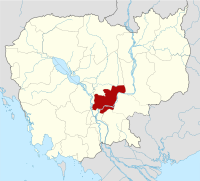
Kampong Cham (Khmer: ខេត្តកំពង់ចាម) is a province in the east of Cambodia. The Mekong river bisects the province. Its capital is Kampong Cham city. With a population of over 1.6 million inhabitants, Kampong Cham is Cambodia's most populous province.
| Country | |
|---|---|
| Capital | Kampong Cham |
| Area | |
| - Total | 9,799 km2 (3,783.4 sq mi) |
| Population (2008)[1] | |
| - Total | 1,680,694 |
| - Density | 171.5/km2 (444.2/sq mi) |
| Time zone | UTC+07 |
| Dialing code | +855 |
| ISO 3166 code | KH-3 |
| Districts | 16 |
| Communes | 173 |
| Villages | 1758 |
Contents[hide] |
[edit] Administration
The district is subdivided into 16 districts(srok), 173 communes (khum) and 1758 villages (phum).[2]- 0301 Batheay (បាធាយ)
- 0302 Chamkar Leu (ចំការលើ)
- 0303 Cheung Prey (ជើងព្រៃ)
- 0304 Dambae (ដំបែ)
- 0305 Kampong Cham (កំពង់ចាម)
- 0306 Kampong Siem (កំពង់សៀម)
- 0307 Kang Meas (កងមាស)
- 0308 Koh Sotin (កោះសូទិន)
- 0309 Krouch Chhmar (ក្រូចឆ្មារ)
- 0310 Memot (មេមត់)
- 0311 Ou Reang Ov (អូរាំងឪ)
- 0312 Ponhea Kraek (ពញ្ញាក្រែក)
- 0313 Prey Chhor (ព្រៃឈរ)
- 0314 Srey Santhor (ស្រីសន្ធរ)
- 0315 Stueng Trang (ស្ទឹងត្រង់)
- 0316 Tbuong Kmoum (ត្បូងឃ្មុំ)
No comments:
Post a Comment